New month is sign that new version of Locus is coming. So what news can you expect?
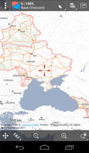
New Online maps: Visicom and Wikimapia
Especially Ukraine users appreciate very detailed Visicom maps which are downloadable for offline usage. We can also mention that these maps can be used also in: Armenia, Azerbaijan, Belarus, Kazakhstan, Kyrgyzstan, Moldova, Tajikistan or Uzbekistan.
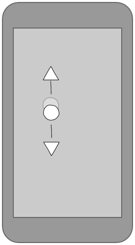
One finger zoom
It’s new function which gives an ability to control zoom with one hand. Tap on the screen and move down or up for zooming.
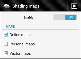
Shaded relief
Locus came with shaded maps in previous version. In version is this functionality improved – you can turn-on shading for all your maps and it doesn’t matter if is online, vector or your personal map. Unfortunately downloading elevation data (*.hgt files) is still little bit tricky – sorry for that.
ANT+ support
Finally support for ANT+ is back – it needs the latest ANT Service (downloadable on Google Play). New Locus version also comes with support for ANT+ thermometer.

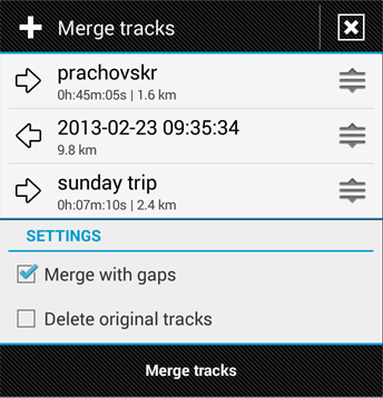
Merging track
Sometimes is needed to merge recorded track into new one. Unfortunately previous version was little bit impotent. For this reason there is new system for merging track in new version. You can define the order of track (simple drag them) and also the orientation of track – you can change start and end point of the track.
Even more
- improved export to GPX files (choosing a version)
- users with small screen appreciate an ability to hide tabs in satellite/compass screen
- another small improvement in vector map speed
- fixed problems with quick zoom, loosing previous state after backup, creating own location sources
- and many more
One finger zoomimproved export to GPX files (choosing a version)
)


2 Comments
Big to you thanks for the Visicom maps! ... they very much didn't suffice to me in locus pro... Thanks!
@Improved export to GPX files (choosing a version): That's cool, now the GPX element link is used for the URL of a POI! This means https://getsatisfaction.com/locus/topics/make_gpx_export_import_use_element_link_for_poi_website is implemented :-)